

NASA's animation of China's Three Gorges Dam construction over the years.

|
Scooped by Trisha Klancar |

Get Started for FREE
Sign up with Facebook Sign up with X
I don't have a Facebook or a X account


 Your new post is loading...
 Your new post is loading...
Your new post is loading...
NASA's animation of China's Three Gorges Dam construction over the years.
Satellites have been watching us for 40 years. Here's what their images reveal.

Ambre Cooper's curator insight,
June 25, 2015 4:04 PM
This is a cool little video. It even shows the level of Aral Sea we read about. 
Hamdou Wane's curator insight,
June 29, 2015 7:55 AM
Satellites have been watching us for 40 years. Here's what their images reveal 
Alex Smiga's curator insight,
August 6, 2017 8:45 AM
Seth Dixon's insight:
This video is simple entry point into the various applications of remote sensing as well as various human and environmental interactions. This video highlights 5 examples: 1. Deforestation (Brazil) 2. Water Use (Aral Sea) 3. Urban Sprawl (Las Vegas) 4. Energy (Coal in Wyoming) 5. Climate Change (Ice Shelf in Antarctica)
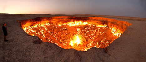
In a world where photoshop has made the unreal seem ordinary, these unearthly seemingly landscapes might seem likely fakes. The world can be that extraordinary. Pictured above is the "Door to Hell" in Turkmenistan. Rich with natural gas, Soviets were drilling in 1971 when the drilling rig collapsed and left a huge (230 feet wide) hole. In an attempt to stop gas leaks they hoped a fire would burn off any discharge, but it is still burning today. Enjoy this gallery of 25 'unnatural' images.

Louis Mazza's curator insight,
March 12, 2015 4:58 PM
Unnatural landscapes. Amongst all the new technology and graphics, the world still holds phenomena’s that can leave any persons jaw dropped. This article on buzzfeed shows 25 images that can amaze you. In Mt. Roraima, Venezuela there is a slab of land that seems to be suspended in the clouds. The Metro in Stockholm, Sweden resembles a space station in the rocks. The tunnel of love in the Ukraine looks like a path carved out of bush and also a romantic place for a date. The tulip Fields in Lisse, Netherlands looks like a grounded rainbow. Lapland, Finland is home to massive natural snow creatures. The mountains of Zhangye, China resembles the colors and look of Zebra stripe gum. Lake Rebta in Senegal looks like your floating in tomato soup. 
Kevin Cournoyer's curator insight,
May 6, 2015 11:43 AM
Physical geography and landforms are something that have amazed people for millennia. The world's tallest mountains, deepest oceans, widest rivers, and largest deserts have, at various times, astounded, baffled, and hindered human beings. Some physical features are helpful to human progress (cities built on hills are more defensible, rivers allow for irrigation for agriculture) and others delay it (mountains are difficult to traverse, oceans are large and treacherous to navigate). And then there are landforms or geographic features that are just downright strange or unusual, like the ones listed in this article.
While looking at pictures of these places or visiting them may be fun, they also provide us with a valuable lesson about nature. Nature is a force to be reckoned with, as it can produce some pretty amazing and unusual things. People sometimes do not stop to think what nature can do and as a result, suffer the consequences (Napoleon, and later Hitler's ill-fated invasions of Russia, for instance). Geography and natural landforms can be invaluable tools in human progress, but it should also be kept in mind that they are part of nature, and that nature is an unpredictable and sometimes violent force. As with anything, then, nature and geography must be respected and feared to avoid making the same mistakes that others have made in the past. 
Nicholas A. Whitmore's curator insight,
December 17, 2015 11:34 AM
Another interesting failure of the Soviets during the Cold War. One really begins to question their competence when reading about this, Chernobyl and the Aral Sea. I honestly don't see how anyone would consider lighting a major gas leak on fire would help the situation either. Regardless this site stands as a testament to the influence we have on the geography of area through our reshaping for society. The incident also now helps Turkmenistan economically because it offers tourist attraction revenue. Additionally while the gallery had many fascinating images from around the world this one captivated me due to its historical nature and affect it would have had on the region. Hopefully the site doesn't ever become too dangerous do to the flammable substances because I would imagine that is a possibility (also hopefully there is not too much environmental damage from it either).
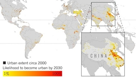
Projections of urban growth indicate areas where biodiversity is at high risk.
The AAG Smart Brief is a fantastic source of geographic news. This is what they said about this article: "Areas such as tropical Africa and eastern China are expected to be hot spots of urbanization during the next several years, according to researchers, who used satellite imagery and other data to project future urban expansion through 2030. 'We're not forecasting population, we're forecasting the expansion of urban space,' said Yale University geographer Karen Seto. Their efforts could be used to assist conservation initiatives, Seto noted."
Tags: AAG, urban, sprawl, land use, urban ecology, biogeography, unit 7 cities, environment.

Lauren Fiedler's comment,
July 24, 2013 7:56 AM
This article is about urban growth and decline, Africa and Asia are predicted to be hot spots of urban growth in the next few years. Geographer Karen Seto of Yale University in New Haven has creted a graph that finally accounts for variations in how individual cities occupy their land and the impact they have on local ecosystems.
Great visual for kids ( and adults) learning about climate change and what we are doing to continue global warming. "Animated time-lapse video of anthropogenic carbon dioxide emissions in map form, spanning the 18th century until this current first decade of the 21st centur...
This is not a complete data set, but the video still shows the striking connection between CO2 emissions and the historical geography of industrialization."
|
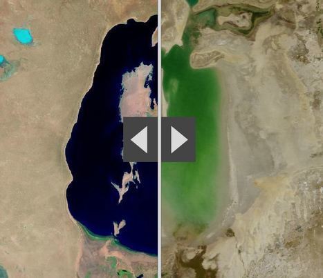
"By moving the slider, the user can compare 1990 false-color Landsat views (left) with recent true-color imagery (right). Humans are increasingly transforming Earth’s surface—through direct activities such as farming, mining, and building, and indirectly by altering its climate."

James Piccolino's curator insight,
March 24, 2018 9:46 AM
Wow. This is depressing. I knew of the Aral sea thanks to class, but the others I had no idea. They were so green and lush way back in the day. Now they are dead and seriously in a sad state. There is nothing wrong with development and advancement, but this is just a lot when it comes to impact.

othni lindor's curator insight,
October 20, 2018 4:01 AM
This map shows how human activities like farming has shaped the Earth's surface. The example they show is the Aral Sea. It is a
regional environmental problem. It is located between the Southern part of Kazakhstan and Northern Uzbekistan. It used to be the world's fourth largest saline lake. Human activities have caused the lake to be almost completely dried up. Over the years, the Aral Sea became polluted with pesticides and chemicals. 
Stevie-Rae Wood's curator insight,
October 28, 2018 9:51 PM
The Aral Sea is a severe environmental issue in Central Asia. This map that we are looking at shows how human activities such as farming have destroyed a natural wonder. The Aral Sea USED to be the fourth largest saline lake but has dried up. The Aral Sea has five times less volume and is five times more saltier than it once was. This occurred because people surrounding the area used more water and used it more intensely. The soviets thought it would be a good idea to use more water projects such as planting cotton, and rice which are water intense crops. This severely dried up the Sea. The area that the sea once was that is now dry land in uninhabitable because of the levels of salt left behind. As well the rivers that connected to the Aral Sea have either dried out or are on the verge of drying out causing many economic problems for those that depended on that water.
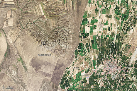
"While people often say that borders aren’t visible from space, the line between Kazakhstan and China could not be more clear in this satellite image. Acquired by the Landsat 8 satellite on September 9, 2013, the image shows northwestern China around the city of Qoqek and far eastern Kazakhstan near Lake Balqash. The border between the two countries is defined by land-use policies. In China, land use is intense. Only 11.62 percent of China’s land is arable. Pressed by a need to produce food for 1.3 billion people, China farms just about any land that can be sustained for agriculture. Fields are dark green in contrast to the surrounding arid landscape, a sign that the agriculture is irrigated. As of 2006, about 65 percent of China’s fresh water was used for agriculture, irrigating 629,000 square kilometers (243,000 square miles) of farmland, an area slightly smaller than the state of Texas. The story is quite different in Kazakhstan. Here, large industrial-sized farms dominate, an artifact of Soviet-era agriculture. While agriculture is an important sector in the Kazakh economy, eastern Kazakhstan is a minor growing area. Only 0.03 percent of Kazakhstan’s land is devoted to permanent agriculture, with 20,660 square kilometers being irrigated. The land along the Chinese border is minimally used, though rectangular shapes show that farming does occur in the region. Much of the agriculture in this region is rain-fed, so the fields are tan much like the surrounding natural landscape."
Tags: remote sensing, land use, environment, geospatial, environment modify, food, agriculture, agricultural land change.

Felix Ramos Jr.'s curator insight,
April 15, 2015 10:24 AM
It is amazing what irrigation can produce. The border between China and Kazakhstan is a perfect picture of land with irrigation and one without supplied water. Eastern Kasakhstan has farmland but it is only subsidized by natural rainfall whereas on the greener Chinese side of the border it is supplemented with water by the farmers. Great picture!
Kevin Cournoyer's curator insight,
May 6, 2015 12:00 PM
Seeing such a striking difference between two countries that are so close together is strange and thought-provoking. Knowing a little bit about the two countries can make a world of difference, though. In this case, we have China and Kazakhstan, two countries located in East/Central Asia. Kazakhstan borders China to the west, along the northern part of its western border. Much of China's inland land use is devoted to agriculture, as the majority of its industry is located near its coast. This is evident by the amount of green space seen in the satellite image above. With well over a billion people to feed, China needs to make use of as much of its arable land as possible. Kazakhstan, on the other hand is a much smaller country with much less land devoted to agriculture. Its farmland is mostly large and industrial, as a result of Soviet-era farming and is rain-fed rather than irrigated, like China's.
Knowing the history as well as the economic strengths of a country can therefore be useful in interpreting satellite images such as the one in this article. A lack of knowledge about China and Kazakhstan's economy and history may lead to an assumption that the Chinese are just better farmers than the Kazakhs. This is of course not necessarily true, but what is true is that China has a much larger and more immediate need for agriculture than does Kazakhstan and so devotes more of its land, time, and energy to farming. Likewise, it shouldn't be assumed that Kazakhstan has no need for agriculture at all. Instead, its history has largely influenced its economic strengths and needs, and the result is a country that looks very different from China. 
Chris Costa's curator insight,
October 19, 2015 12:41 PM
It's crazy to see how much human influences can reshape the landscape, or how things we tend to think of in more abstract terms- like national boundaries- can be very physical in nature. I liked reading about the differing agricultural approaches the two nations take, and being able to see the physical manifestations of those two different approaches so obviously. It's impressive to think that China is able to support such a massive population- one in every 5 people alive on the planet is Chinese- with so little land, and the consequences are plain to see in the image above. Increased irrigation efforts leads to the unnaturally bright green patches in the middle of a relatively dry area, serving as a symbol of man's attempts to bind mother nature to his will. Although not always successful, such attempts appear to be working well here. In contrast, Kazakhstan's population demands vary wildly from that of China's, and its solution for feeding its people can therefore take a more natural, backroads approach, with food production concentrated in a few areas. I wonder what other international borders can be seen so neatly with the naked eye.
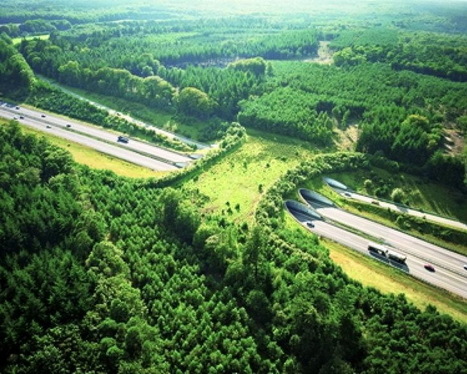
Our modern society depends on greater connectivity between places. Regionalized economies, politics and transportation networks are increasingly integrated with far-flung places now more than ever before. Our biosphere and natural environments are exceptions to this pattern. Wilderness areas are 'islands' in an ocean of human controlled environments. We create transportation linkages that unite people economies and cities, but separate herds from there extended habitat.
We've all seen road kill on major highways. Species like deer, elk, and grizzly bears and other large-bodied animals need a wide range for numerous ecological reasons. These bridges are an attempt to ameliorate some of the problems that our roads pose for the non-human species that still call Earth home. From a purely economic standpoint, many argue that these bridges save society money given the accidents and property damage that can be avoided.
Tags: biogeography, transportation, environment, land use, sustainability, environment adapt.

Carly Schaus's comment,
October 3, 2013 9:48 PM
I think this would be a great idea! it would keep the animals, nature and people safe. They have protection from motor vehicles where they crash on.

Courtney Gritman's comment,
October 4, 2013 3:22 PM
I think this would be a wonderful solution from innocent animals from being killed and thousands of car accidents being prevented.
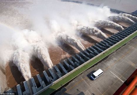
"The final 32 generators went into operation this week, making it the world's largest hydropower project, pictured, built on the Yangtze River in China." This photo gallery has a tremendous video at the end that displays vividly the raw power that moves the turbines. Economically, what are the benefits? Environmentally, what are the costs?
Via John Foden

Amanda Morgan's curator insight,
December 15, 2014 4:07 PM
The three gorges dam displays the extraordinary things man can do to manipulate the environment. This man made dam also shows how much technology influences our geographic space.
|


The impact of the Three Gorges Dam on the residents upstream is amazing. I cannot imagine anything like this happening in the US, mostly because of the impact on the people both upstream and downstream. Ecological damage from this dam may not phase the Chinese government, but I think any North American or European government would shudder at the thought of the backlash among their citizens this would create.
Three Gorges damn in China is the largest dam ever constructed. This was created to save on power by creating hydroelectric power for the people of the land. One of the issues with this was the the flooding of the land up streams displacing millions of people. It created a larger up stream area and very small down stream. A lot of the people that lived up stream had to be relocated further inland and faced changing climatif weather. The banks of the river are carved out between what seems like mountainous regions so as you move more uphill the weather and temperature will be a whole new category of life (Depending on how far you relocated).