Eclectic Technology
224.6K views | +0 today
Follow
Eclectic Technology
Tech tools that assist all students to be independent learners & teachers to become better teachers
Curated by Beth Dichter
Your new post is loading...
Scooped by Beth Dichter
Scoop.it!

Atlas of the Historical Geography of the United States

Atlas of the Historical Geography of the United States | Eclectic Technology | Scoop.it

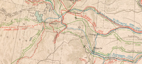
"Here you will find one of the greatest historical atlases: Charles O. Paullin and John K. Wright's Atlas of the Historical Geography of the United States, first published in 1932. This digital edition reproduces all of the atlas's nearly 700 maps. Many of these beautiful maps are enhanced here in ways impossible in print, animated to show change over time or made clickable to view the underlying data—remarkable maps produced eight decades ago with the functionality of the twenty-first century."

Beth Dichter's insight:

This old atlas provides new functionality due to technology! Maps have been georectified, many are animated allowing you to see a progression over time, many are clickable providing access to data such as population demographics or crop production, and much more. Have fun exploring.

No comment yet.
Scooped by Beth Dichter
Scoop.it!

TimeMaps - World History Atlas combining maps, timelines, narratives

TimeMaps - World History Atlas combining maps, timelines, narratives | Eclectic Technology | Scoop.it
The FREE TimeMaps Atlas of World History is an award winning website for navigating around the big picture of world history or for taking a look at particular civilizations, nations or empires.
No comment yet.
Scooped by Beth Dichter
Scoop.it!

5 Great Mapping Tools to Use in the Classroom

5 Great Mapping Tools to Use in the Classroom | Eclectic Technology | Scoop.it
Fantastic mapping tools, each with brilliant interactive ways for students to get involved and literally put themselves on the map in new and exciting ways!
Beth Dichter's insight:

The five mapping tools discussed are:

* QuikMap - allows you to doodle on Google maps

* Atlas - add photos and comments to maps

* Mapskip - share stories, pictures, videos and sound recordings about all the places in our lives

* VidMap - add video and audio to maps

* If It Were My Home - allows you to compare living conditions in your country to other countries

All are free and all provide great options for students to explore maps in new dimensions.

Gabrielle's curator insight, May 14, 2017 10:05 PM
Great resources on Digital mapping. All interactive